


Q: Why are U.S. construction firms shifting to hybrid global engineering teams?
A: Because hybrid teams help firms process survey data faster, reduce BIM/CAD bottlenecks, and maintain 24/7 engineering workflows. They also cut engineering costs by 30–50% while improving accuracy and project delivery speed.
The construction and civil engineering landscape in the United States is changing rapidly. Urbanization, increased spending on infrastructure, labour shortages, strict regulations, and growing project complexities have pushed the industry to adopt a more digital, data-driven, and collaborative approach. In this shifting environment, Digital Surveying Services USA are key to executing projects faster, more efficiently, and more accurately.
At the core of this change is a new operating model: hybrid global engineering teams. These teams blend U.S.-based project leaders with offshore engineering and digital surveying expertise. This structure enables construction and civil firms to work around the clock, cut overhead costs, speed up design approvals, and enhance overall project outcomes. Firms are increasingly viewing civil engineering outsourcing not just as a cost-saving measure, but as a way to drive innovation, scalability, and timely project delivery.
24/7 Engineering Cycles That Speed Up Project Delivery
As U.S. firms adopt more digital tools, the demand for digital surveying services USA, civil engineering outsourcing, and hybrid global engineering teams continues to rise.
Learn more about our full-range engineering services
Top Benefits of Hybrid Global Teams
- Faster survey data processing
- Lower engineering costs
- 24/7 design cycle
- Reduced BIM rework
- Faster approvals
Engon Technologies is leading the way in supporting U.S. construction, infrastructure, and EPC companies with digital surveying solutions, BIM and CAD outsourcing, and comprehensive construction engineering support. This article explores why hybrid global teams have become essential for U.S. firms, how outsourcing speeds up civil project delivery, and how digital surveying improves precision in land development, transportation, energy, and large-scale construction projects.
Rise of Digital Surveying Services in Construction and Civil Engineering
Why Hybrid Global Engineering Teams Are Increasing in the U.S.
Traditionally, the construction industry has been slow to embrace new technologies, but the last decade has seen significant change. This shift is driven by the need for faster execution, better accuracy, and more efficient use of resources. Today, U.S. firms rely on digital tools like LiDAR scanning, GIS platforms, advanced drones, 3D mapping, and geospatial services to enhance the quality of land surveys and site data. These advancements also increase demand for 3D laser scanning services USA, especially for high-accuracy infrastructure projects.”
Digital Tools Powering Modern Digital Surveying Services (LiDAR, Drones, GIS, 3D Mapping)
Old surveying methods can no longer meet the demands of modern infrastructure. Digital surveying solutions, paired with cloud-based engineering tools, enable contractors and engineering teams to create detailed, high-accuracy digital representations of job sites. These datasets are crucial for planning, design, permitting, and clash detection. As reliance on digital tools increases, so does the need for skilled engineering teams to process large amounts of data, pushing companies to embrace hybrid outsourcing models.
U.S. construction project engineering workflows have become complex. They now involve topographical surveys, structural design, utility coordination, environmental analysis, BIM modelling, CAD drafting, and digital validation techniques. This complexity demands diverse talent, advanced software skills, and the ability to manage multiple tasks at once. Hybrid global teams offer the ideal solution by merging local decision-making with global technical execution. Independent infrastructure-efficiency research by McKinsey shows how hybrid global engineering teams shorten project cycles and reduce project-development costs.
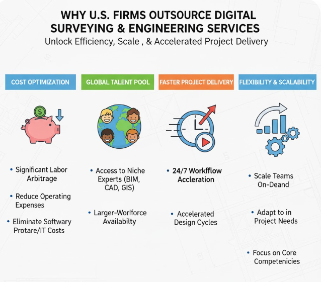
Why U.S. Firms Choose Civil Engineering Outsourcing & Digital Surveying Services USA for Faster, More Accurate Project Delivery
Addressing the U.S. Shortage of BIM, CAD & Surveying Talent
The rise in outsourcing is driven by several challenges affecting the construction and civil sectors. One major issue is the nationwide shortage of qualified engineers, surveyors, and drafting professionals. Construction firms have difficulty hiring and keeping full-time specialists in surveying, 3D mapping, BIM, and CAD modelling. This shortage leads to delays, inefficiencies, and higher project risks. The ongoing labor shortage among U.S. civil engineers reported by ASCE highlights why firms struggle to hire surveying, drafting, and BIM specialists in-house.
According to BLS civil-engineer projections (2024–34), demand for engineering talent will continue outpacing supply, making outsourcing essential for maintaining productivity.
By adopting civil engineering outsourcing models, companies can quickly access a skilled global workforce. These teams can handle surveying data processing, CAD development, structural drafting, planning documentation, and digital engineering analytics. Outsourcing allows U.S. teams to focus on site management, contract administration, inspections, client coordination, and regulatory approvals, while offshore teams take care of the technical work needed for project progression.
Growing Demand for CAD Drafting Outsourcing USA
Cost optimization also drives outsourcing. Keeping a full-time, in-house engineering team is costly, especially for firms managing multiple projects with varying engineering needs. A hybrid team offers a flexible engineering workforce, letting companies adjust staffing based on project phases. This flexibility helps maintain budgets, improve profitability, and minimize the risks linked to overstaffing or understaffing.
Another reason firms outsource digital surveying and engineering services is the demand for faster land survey data processing. Digital surveying tools produce vast amounts of raw geospatial data, including point clouds, terrain maps, elevation models, and 3D site scans. Many contractors now rely on LiDAR surveying USA to capture detailed terrain and elevation data. Processing this data manually is time-consuming and labour-intensive. Offshore engineering teams, skilled in advanced software and large-scale data processing, can convert raw data into usable deliverables quickly, ensuring that planning and construction schedules stay on track.
How Hybrid Global Teams Accelerate Construction and Civil Project Delivery
Faster Survey-to-CAD and Survey-to-BIM Processing Pipelines
Hybrid global engineering teams work around the clock, keeping work moving even after U.S. teams finish their day. This 24-hour engineering cycle significantly reduces delivery timelines. When surveyors or field teams upload datasets, offshore engineers begin processing them right away. By the next morning in the U.S., refined drawings, terrain models, and design updates are ready for review. This level of efficiency is hard to achieve with only local teams.
The combination of digital surveying solutions and remote engineering collaboration also boosts accuracy. Instead of relying on fragmented or incomplete data, hybrid teams create integrated digital models that encompass geospatial data, utility layouts, design alignment details, and structural frameworks. This minimizes design conflicts and speeds up construction approvals. This hybrid workflow strengthens the quality of engineering surveying services USA, ensuring accuracy from survey to design. Outsourcing BIM and CAD tasks further enhances precision because offshore specialists focus entirely on producing detailed models, clash detection reports, and updated drawing sets.
Hybrid global teams are vital in supporting infrastructure design outsourcing. Large-scale civil projects, such as highways, bridges, rail corridors, water systems, land development, renewable energy zones, and utility expansions, require extensive engineering documentation. Outsourcing enables U.S. companies to manage multiple projects at once without sacrificing quality or deadlines. Offshore teams serve as the engineering backbone, managing alignment drawings, grading plans, utility routing, structural detailing, and environmental documentation.
The Growing Importance of Digital Surveying Services USA in U.S. Infrastructure Projects
High-Accuracy Terrain Models for DOT & Municipal Submittals
Digital surveying has become the basis for efficient project planning. The shift from traditional surveying to digital tools is fuelled by the need for accuracy, speed, and reliable data. Drones, LiDAR scanners, and cutting-edge 3D mapping technologies enable more precise site measurements and visualizations. Drone adoption is rising quickly, making drone surveying USA one of the fastest-growing mapping solutions. The large datasets created by these tools provide a thorough understanding of terrain features, land conditions, slopes, utilities, and surrounding infrastructure.
Digital surveying aid for U.S. contractors and EPC companies supports better decision-making throughout the project lifecycle. Accurate land survey models help reduce rework, improve material estimates, guide machine-control systems, and prevent costly design errors. Modern projects now expect land surveying services USA to deliver precise digital measurements for planning. With hybrid teams, digital surveying becomes even more effective, as teams can process data at scale, produce 3D surfaces, create digital elevation models, and develop accurate topographical plans more quickly.
This shift is especially notable in infrastructure modernization projects backed by federal and state funding. Highways, bridges, water pipelines, and public utilities need constant upgrades, and precise surveying is vital for meeting regulatory and safety standards. Hybrid global teams enhance this process by ensuring U.S. firms have ongoing access to skilled surveying processors and CAD technicians who deliver accurate documentation for submission and approval.
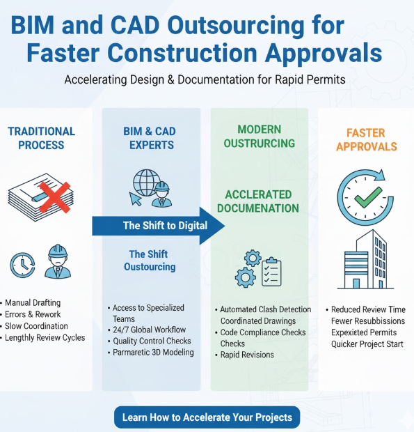
BIM and CAD Outsourcing for Faster Construction Approvals
Reducing Approval Delays Through Coordinated BIM Models
One of the biggest delays in U.S. construction is the lengthy approval process for designs, permits, and regulatory submissions. BIM and CAD outsourcing can speed up this phase by ensuring that contractors, civil engineers, and architects receive timely and detailed digital models. Many U.S. builders now follow ISO 19650 BIM standards to improve coordination, documentation structure, and approval readiness. Offshore specialists create building information models, structural detailing sheets, MEP coordination drawings, and clash detection reports that help minimize conflicts during construction.
BIM Outsourcing USA for Faster Approvals
Choosing a hybrid global team boosts BIM productivity because tasks that usually take weeks can be completed in days. As U.S. teams review updates or submit revisions, offshore engineers simultaneously refine models and resolve issues. This continuous process enhances communication among stakeholders, leading to faster approvals and fewer revisions from regulatory agencies.
In the U.S. construction project engineering ecosystem, BIM has become crucial for reducing risks, forecasting budgets, and coordinating on-site work. Outsourcing BIM speeds up document readiness, which is critical for quicker project launches. For EPC companies managing multiple simultaneous projects, hybrid teams are essential for ensuring timely and accurate BIM documentation.
The Role of Geospatial and 3D Mapping Services in Modern Construction
Geospatial Insights for Environmental & Utility Risk Analysis
Geospatial technology has advanced beyond basic mapping tasks. Today, geospatial analytics is crucial for land development, environmental studies, utility planning, and site evaluations. With geospatial services and 3D mapping, U.S. firms gain enhanced visualizations of terrains, underground utilities, transportation corridors, vegetation cover, water flow patterns, and land-use features. Contractors increasingly request geospatial mapping services USA to support environmental and utility planning.
Hybrid global teams bolster these efforts by accurately processing geospatial data and creating models that work seamlessly with design engineering tools. This allows design teams and contractors to foresee challenges before construction starts. Correct geospatial datasets also assist in assessing climate impacts, flood risks, soil erosion zones, and meeting environmental compliance requirements.
For Engon Technologies, combining surveying, geospatial analysis, and digital engineering creates a robust ecosystem. It helps U.S. firms reduce site uncertainties and enhance the resilience of infrastructure over the long term.
Why Hybrid Global Teams Are the Future of U.S. Construction and Civil Engineering
Combining Local Oversight with Global Engineering Expertise
The shift towards hybrid global teams is not just a passing trend—it represents the future of civil engineering outsourcing. As construction projects become more intricate, firms need flexible workflows, consistent output, and specialized skills. Hybrid teams offer the perfect combination of on-site experience and offshore engineering know-how.
U.S. teams continue to manage client communication, site inspections, contract management, and regulatory coordination, while global teams oversee BIM production, CAD drafting, surveying data processing, design detailing, and documentation. This collaboration brings together the strengths of both groups to create a unified, efficient, and scalable engineering environment.
The growing use of digital engineering tools only increases the need for global teams. Modern construction requires regular updates to digital models, ongoing validation of survey data, and constant engineering support. Hybrid teams ensure this continuous workflow.
Why U.S. Construction and Civil Firms Prefer Engon Technologies
Engon’s Expertise in Surveying, BIM, CAD & Geospatial Engineering for Digital Surveying Services USA
Engon Technologies has built a reputation as a reliable partner for Digital Surveying and Engineering Services USA by providing highly skilled global engineering teams, deep knowledge in the field, and a commitment to accurate and timely results. Engon specializes in supporting construction engineering across land development, transport infrastructure, utilities, industrial sites, renewable energy zones, and large-scale civil structures.
Engon Technologies hybrid global engineering teams work closely with U.S. offices, providing continuous project support through remote collaboration and digital integration. The company delivers advanced digital surveying solutions, thorough BIM and CAD outsourcing, structural and civil engineering services, and complete geospatial processing support. Its end-to-end model ensures that even the most challenging construction projects receive accurate engineering deliverables on time.
Real-World Case Studies: How Hybrid Global Teams Transform U.S. Construction & Civil Engineering
CASE STUDY 1: Hybrid Global Engineering Teams Help U.S. Civil Contractor Cut Delivery Time by 45%
A mid-sized civil engineering and construction contractor in Texas was struggling to keep up with survey data processing, CAD drafting, and BIM updates for multiple roadway and utility improvement projects.
Their in-house drafting team was overloaded, resulting in:
- Delayed design reviews
- Backlogs of survey data
- Slow permit submissions
- Escalating engineering costs
Engon’s Hybrid Solution
Engon Technologies deployed a hybrid global engineering team combining U.S.-based coordination with offshore CAD, BIM, and digital surveying specialists.
They handled:
- Processing LiDAR point clouds
- Generating topographic surfaces & grading plans
- Creating alignment sheets, utility layouts, and cross sections
- Running BIM updates and clash detection overnight
Results
- 45% faster design delivery
- Zero bottlenecks in survey-to-CAD pipeline
- Round-the-clock engineering cycle (U.S. work by day, offshore updates at night)
- Saved ~$180,000/year in staffing and software costs
Impact:
The contractor finished their DOT submittals ahead of schedule for the first time in 4 years.
CASE STUDY 2: BIM Case Study: How Engon Technologies Helped a Construction Contractor Deliver a Fully Coordinated Commercial Building Project Using Digital Engineering Services
Project Overview
A leading construction contractor in the U.S. faced delays on a mid-rise commercial building project. Civil, structural, and architectural teams were working with separate 2D drawings, which created repeated mismatches and costly on-site rework.
To solve this, the contractor partnered with Engon Technologies, a global engineering company offering advanced digital engineering services and BIM support.
Challenges Before Engon Technologies Implemented BIM
- Civil layouts and architectural plans were not aligned
– Example: Column placements clashed with door openings and staircase widths. - Frequent construction rework
– Slabs, beams, MEP routes required corrections on-site. - Slow approval cycles
– The client could not visualize the building from 2D drawings. - Paper-based workflows
– Hard to track changes across the civil, architecture, and construction teams.
Engon Technologies’ Digital Engineering Approach
Engon Technologies deployed a dedicated BIM team to create a full 3D coordinated building model using:
- Civil engineering drawings
- Architectural layouts
- Structural design
- MEP systems
Tools Used
- Autodesk Revit
- Navisworks Manage
- BIM360 for collaboration
- 3D Scan integration (where available)
Engon’s digital engineering services unified all disciplines into one model.
Key BIM Solutions by Engon Technologies
Clash Detection & Resolution
Engon identified clashes between civil, architecture, structural, and MEP systems, such as:
- Ducts cutting through beams
- Plumbing lines intersecting electrical conduits
- Foundation levels mismatching architectural floor plans
Over 320 clashes were resolved before construction.
Coordinated Drawings for Site Execution
Engon delivered:
- Combined architectural + civil plans
- Structural + MEP integrated layouts
- Detailed shop drawings
- Clear section views and elevation details
This eliminated confusion for the on-site construction team.
Quantity Take-Offs & Cost Optimization
Using BIM, Engon calculated:
- Concrete volume
- Steel quantities
- Material lists
- BOQs and cost estimates
This allowed the contractor to plan procurement more effectively.
Faster Client & Municipality Approvals
The 3D BIM model helped:
- Visualize the design clearly
- Reduce revision cycles
- Speed up client approvals
- Simplify permit approvals
Results After Engon Technologies’ BIM Deployment
Impact Area | Outcome |
Clash reduction | 95% design conflicts removed |
Rework savings | 18–22% cost savings |
Project timeline | 30% faster completion |
Drawing accuracy | 100% coordinated drawings |
Site productivity | Major improvement in execution clarity |
Client satisfaction | Faster approvals & better visualization |
Why the Contractor Continues to Work with Engon Technologies
Because Engon provides:
- Highly skilled digital engineering services
- Fast turnaround BIM execution
- Precise civil + architectural + structural coordination
- Strong communication with on-site teams
- Cost-effective engineering for global projects
The contractor has now partnered with Engon Technologies for multiple future projects, including hotels, commercial offices, residential buildings, and industrial facilities.
Conclusion
Engon Technologies proved that BIM + digital engineering services can eliminate rework, speed up approvals, reduce cost, and ensure civil, architecture, and construction teams work from one unified model.
This case study shows how Engon transforms traditional construction projects into smarter, faster, and more predictable engineering outcomes.
Conclusion
The growing adoption of digital surveying services, BIM workflows, geospatial mapping, and hybrid engineering support is transforming how U.S. construction and civil engineering projects are delivered. By combining advanced digital technologies with skilled global engineering teams, firms can improve project accuracy, accelerate design cycles, reduce operational costs, and meet increasingly demanding schedules.
Hybrid engineering models enable U.S. contractors, EPC firms, and infrastructure developers to access specialized surveying, CAD, BIM, and geospatial expertise while maintaining local project oversight. This approach supports faster project execution, better collaboration, and more predictable outcomes across transportation, land development, utility, energy, and construction projects.
Engon Technologies helps U.S. firms streamline engineering workflows through digital surveying services, BIM and CAD support, geospatial data processing, and scalable engineering resources. By blending local leadership with global technical expertise, we help clients deliver projects with greater efficiency, accuracy, and confidence.
Looking for reliable digital surveying and engineering support for your next project? Contact Engon Technologies to explore how our hybrid engineering teams can help accelerate project delivery and improve project outcomes.